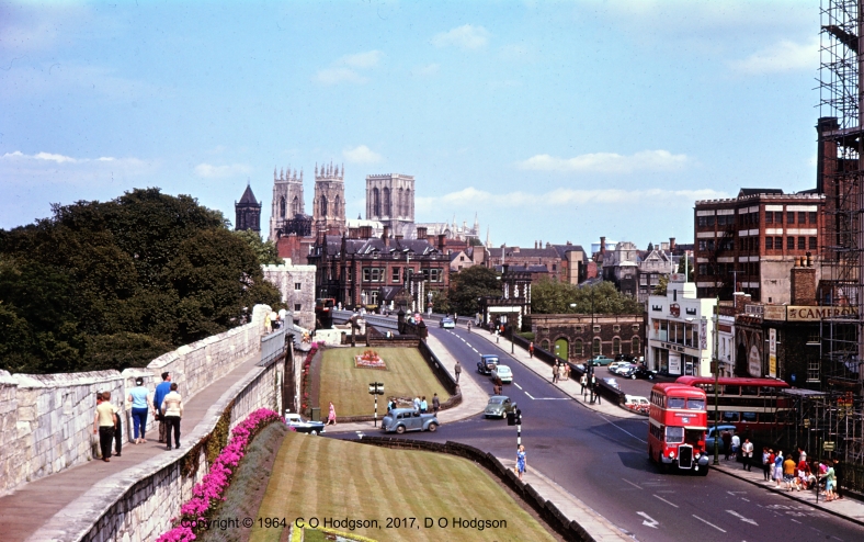
York from the City Walls, August 1964
There are many stereotypes of Yorkshire, with varying degrees of truthfulness, but I suspect that people rarely, if ever, associate Yorkshire with Latin. As a child, growing up in Yorkshire, however, I learned that there is a definite Latin influence in the county, at least as far as place names are concerned.
My father photographed the above view of York long ago, but you can still take the same view today, and little has changed there, except for the traffic.
I realize that the conjunction of the concepts “Yorkshire” and “Latin” may conjure up visions of a red-faced George Whitebread (Harry Enfield’s Yorkshireman character) declaring something like, “Latin? Don’t talk to me about Latin. I’ve been to Benidorm!”, but that’s not what I’m thinking of here.
In fact, there are many placenames in Yorkshire that are directly or indirectly derived from Latin words. Some of the “indirect” derivations stem from the Old French or Anglo-Norman languages, which were themselves descendants of Latin.
Roman Legacy
On reflection, the occurrence of Latin names anywhere in England shouldn’t really be surprising, since Yorkshire and the rest of what’s now England were a part of the Roman Empire for several hundred years.
Typically, where the Romans developed an existing settlement, they would name it by Latinizing its existing local name. In what’s now England, those names are typically of Celtic origin, and in many cases the Celtic meanings of the names remain unknown.
The Roman names of many English settlements are known, but in general those names are no longer in use, having been replaced by new names created by later settlers. However, there are a few cases where the Latin name has survived in a more or less obvious form.
As an example that’s not in Yorkshire, the name Lincoln is probably closest to the Latin original, which was Lindum Colonia. All you need to do is to cross out a few letters!
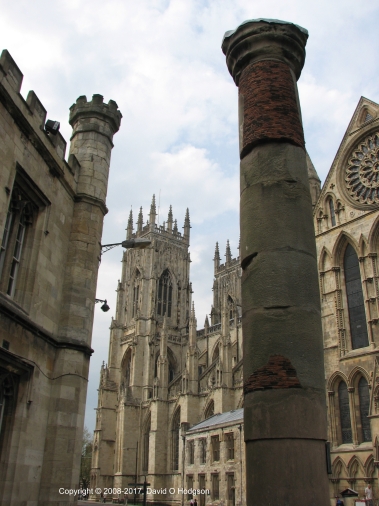
Roman Column in York, which was originally part of the Basilica. It was found under York Minster, in the background
The name of Yorkshire’s capital city, York, is of Latin origin, but less obviously so. The Latin name was Eboracum, which was probably derived from the Celtic Caer Ebruac. The Roman name was changed to the Old English Eorforwic, and then to Jorvik by the Vikings. The current name is just a modified version of Jorvik.
As a schoolchild in Yorkshire, it was drilled into me that a person from York is not referred to as a “Yorker”, or anything like that, but as an Eborian, because of the Latin name of the city.
Religious Influence
Following the Norman Conquest, England and parts of what is now France were unified under a single king, as the Angevin Empire. As a result, cultural influences from the continent began to drift into England. At that time, religious houses such as monasteries were the repositories of much learning and tradition. The language of the Western church was still Latin, so there was a natural tendency to apply Latin names to objects.
The language of the Norman court was Anglo-Norman, which was itself a derivation of vulgar Latin. French is one of several modern European languages that are derived from Latin, and are known collectively as Romance languages.
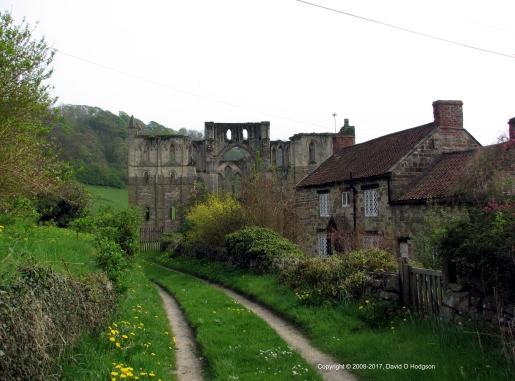
The Ruins of Rievaulx Abbey, Yorkshire, in 2008
Usually, when a new monastery was founded, it would adopt the existing local name. However, sometimes monasteries were founded in previously-uninhabited places, so a new name had to be invented. This happened at Rievaulx, where the modern name is a corruption of the Latin Rye Vallis. The pronunciation of the name has also changed over the years; the current pronunciation is “Ree-voh”, but it seems that this was a change that occurred only after the majority of the population learned to read, and discovered how the word is spelled. Prior to that, the accepted pronunciation was apparently “Rivers”.
Latin prefixes and suffixes have also been applied to some placenames. The suffixes Magna and Parva are used in Yorkshire and in other counties. However, one Latin suffix that seems to appear only in Yorkshire applies to the neighboring villages of Low Hutton and High Hutton, which together are known as Huttons Ambo (and which was the name of their railway station). During my recent Spanish lessons, I learned that the Spanish for “both” is ambos, because of course Spanish is another of those Romance languages.
Another Old French name that appears in Yorkshire is that of the village of Grosmont. In this case, the village is named after a medieval priory that was founded at that site by a religious order based in what is now France. Scenes around Grosmont featured quite regularly in the ITV police drama Heartbeat, and the location of the fictitious town Ashfordly corresponded to that of Grosmont.
The Norman Influence: Radio Active
Writing this article reminded me of a sketch from the 1980s-vintage BBC radio comedy show Radio Active.
As part of the “God Alone Knows” show, DJ Martin Brown is interviewing church warden Clifford about the history of St. Littlebody’s Church:
Martin Brown: “This is not a new church, is it? Is it eighteenth century, Clifford?”
Clifford: “No it’s Norman in fact”
Martin Brown: “Oh I’m sorry. Erm, is it eighteenth century, Norman?”
Clifford: “The church is Norman”
Martin Brown: “Oh I’m sorry. So, Clifford, how did you come to call the church Norman?”
Clifford: “I didn’t call the church Norman”
Martin Brown: “Oh no, sorry. Silly me. It was probably called Norman hundreds of years ago, wasn’t it? Possibly by the Normans, who knows?”
You can hear this sketch in its full glory, along with the rest of the Radio Active episode “God Alone Knows”, at this site:
https://archive.org/details/RadioActiveBBC


 I took the photo above, showing the church of