
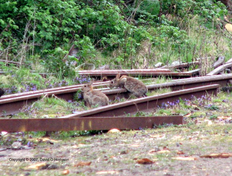
Fictitious Temple in Silchester, c.500 CE
In previous posts, I’ve published some of my own efforts at poetry. This time, I’m publishing a poem by someone else, called “The Ruin”. However, I’m not worried about copyright infringement issues, because not only is the work very long out of copyright, but in fact nobody knows who wrote it!
My watercolor painting above, showing the ruins of a fictitious Roman temple in what’s now England, was partially inspired by the poem. However, the poem I’m discussing here is thought to refer to the city of Bath, while, for various reasons, my ruin was supposed to be in Silchester.
Before discussing the history of the poem, and some thoughts on Roman ruins in Britain, here is the poem itself in the original Old English. (In a previous post on my professional blog, I discussed some of the letters used in Old English, and which appear here.)
Of course, English has changed so much during the past thousand years that no speaker of Modern English can read this without treating it as a foreign language. Nonetheless, the original poem has a beautiful flow and structure, which can be appreciated even if you don’t understand what it actually says.
Unfortunately, the surviving manuscript of the poem is damaged, such that some of the text is either unreadable or missing. In the rendering below, the ellipses show where text is illegible. The punctuation is modern.
The Ruin (Old English)
Wrætlic is þes wealstan, wyrde gebræcon;
burgstede burston, brosnað enta geweorc.
Hrofas sind gehrorene, hreorge torras,
hrungeat berofen, hrim on lime,
scearde scurbeorge scorene, gedrorene,
ældo undereotone. Eorðgrap hafað
waldend wyrhtan forweorone, geleorene,
heardgripe hrusan, oþ hund cnea
werþeoda gewitan. Oft þæs wag gebad
ræghar ond readfah rice æfter oþrum,
ofstonden under stormum; steap geap gedreas.
Wonað giet se …num geheapen,
fel on …
grimme gegrunden …
scan heo…
…g orþonc ærsceaft
…g lamrindum beag
mod mo… …yne swiftne gebrægd
hwætred in hringas, hygerof gebond
weallwalan wirum wundrum togædre.
Beorht wæron burgræced, burnsele monige,
heah horngestreon, heresweg micel,
meodoheall monig mondreama full,
oþþæt þæt onwende wyrd seo swiþe.
Crungon walo wide, cwoman woldagas,
swylt eall fornom secgrofra wera;
wurdon hyra wigsteal westen staþolas,
brosnade burgsteall. Betend crungon
hergas to hrusan. Forþon þas hofu dreorgiað,
ond þæs teaforgeapa tigelum sceadeð
hrostbeages hrof. Hryre wong gecrong
gebrocen to beorgum, þær iu beorn monig
glædmod ond goldbeorht gleoma gefrætwed,
wlonc ond wingal wighyrstum scan;
seah on sinc, on sylfor, on searogimmas,
on ead, on æht, on eorcanstan,
on þas beorhtan burg bradan rices.
Stanhofu stodan, stream hate wearp
widan wylme; weal eall befeng
beorhtan bosme, þær þa baþu wæron,
hat on hreþre. þæt wæs hyðelic.
Leton þonne geotan …
ofer harne stan hate streamas
un…
…þþæt hringmere hate
…þær þa baþu wæron.
þonne is …
…re; þæt is cynelic þing,
huse… burg…
The Waters of Sul
As I mentioned above, it is frequently suggested that the poem describes the remains of the City of Aquae Sulis (“the Waters of Sul”) — the modern City of Bath — but that’s simply an educated guess. The manuscript provides no helpful footnotes nor explanatory detail, so the actual subject of the poem will probably never be known for sure.
Aquae Sulis probably succumbed to a similar fate to that of other conurbations, falling into disrepair some time soon after the empire’s legions were withdrawn from Britannia in 410 CE. After the Roman engineers departed, their Anglo-Saxon replacements were either unable or unwilling to maintain the complex stone buildings, and so either left them to disintegrate, or else removed the materials for other uses. Very little is known regarding the process of this decay, during the period called (for that very reason) the “Dark Ages”, so the existence of this poem offers a rare insight into the conditions of that time.
The Exeter Book
The book containing the only surviving manuscript of the poem is so-called, not because it was written in or about the City of Exeter, but because it forms part of the collection of Exeter Cathedral. The book consists of a sequence of unrelated literary works, including everything from epic poetry to risqué riddles. Its contents appear to have been copied out, by a single scribe, in about 975 CE, although most, if not all, the works contained in the book seem to have been created at earlier dates.
It is known that the book was owned by Bishop Leofric of Exeter until 1070, when he donated it to the cathedral’s library. However, there’s no evidence that the book was held in particularly high regard. Indeed, there is evidence that its front cover was used, at various times, as a cutting board and a beer mat! Some folios are missing, and the fourteen surviving pages nearest to the back have been burned.
The folio containing the poem itself is damaged, which has rendered portions of the middle and end of the poem illegible. Nonetheless, the remaining text provides an extraordinary description of the awe in which the Anglo-Saxon community must have held the crumbling remains of the Roman cities around them.
The Structure of the Poem
The poem exhibits characteristics typical of Old English verse, which distinguish such works from later poetry.
Perhaps the most obvious feature is the caesura in the center of each line (marked by commas or periods above), which imposes a syntactical structure leading to the enjambment of many of the lines.
Another typical feature is the lack of the use of rhyme, which is ironic when one considers that, due to its inflected nature, it was much easier to find rhyming pairs in Old English than in its modern equivalent.
Conversely, very heavy use was made of alliteration (e.g., “weallwalan wīrum” for “iron bonds”), although it is almost impossible to retain this feature in any modern translation.
It’s a real stroke of luck that this remarkable example of historic literary description has survived for us to read, although it makes you wonder how much similarly wonderful literature must have been lost.
Modern English Translation
Although there are no copyright concerns regarding the original Old English version of the poem, most modern translations of it are, of course, subject to copyright restrictions. However, the Wikipedia article about the poem offers one translation:
https://en.wikipedia.org/wiki/The_Ruin
Stumbling on Silchester
At the time that I first learned about this poem, I was living in Andover, UK, and commuted to my job in Wokingham, about 40 miles away. I took several circuitous rural routes between the two locations, depending on traffic and weather conditions. One such route took me past what is now a tiny hamlet called Silchester.
Unlike Bath, Silchester was never repopulated as a city after the post-Roman abandonment. At Silchester, the only remains above ground are portions of the huge city walls, which now surround an empty field. I plan to say more about Silchester in future posts.


