Architectural Redevelopment: Vandalism or Progress?

St. Pancras International Station, London, 2010

St. Pancras International Station, London, 2010

In 2010, I visited a spectacularly transformed St. Pancras Station in London, for the first time since I had lived in the city. In the photograph (below) taken during a 1981 visit, St. Pancras was a dowdy, run-down relic, the only possible future for which seemed to be closure and demolition.

St. Pancras Station, 1981

St. Pancras Station, 1981

But, thankfully, it was not to be, partly due to the efforts of one man, and instead, the huge Victorian edifice was not only saved, but was transformed into the impressive, functional St. Pancras International Station. The photograph below shows the beautiful and airy interior of the trainshed of St. Pancras International, on a day when a German ICE train was visiting to promote future usage of the station by DB.

Interior of St. Pancras International Station, 2010

Interior of St. Pancras International Station, 2010

Although the redevelopment of St. Pancras is one of the most internationally famous triumphs of architectural rehabilitation, there have been many other examples of success and failure.

Yesterday, someone posted on the Facebook page of my alma mater, Imperial College, a photograph of the Imperial Institute, which was a predecessor building in South Kensington, the site of which is now occupied by Imperial College. That reminded me of the many heated battles that have occurred during my lifetime over architecture, and the demolition or redevelopment of buildings. In the past, the usual result was demolition, but, during the past twenty years or so, more enlightened thinking has prevailed, resulting in such wonderful renovations as St. Pancras.

During the 1960s (long before I became a university student), the Imperial Institute building was the focus of a heated dispute between those who wanted to demolish the Victorian edifice completely, and those who wanted to preserve it.

The redevelopers of the Imperial College campus wanted to sweep away all the Victorian architecture and replace it with what they considered to be modern and functional structures.

However, an organization called the Victorian Society, led by the poet Sir John Betjeman, fought for the preservation of Victorian architecture, and became particularly involved in the Imperial College plans. Although they were not able to save everything, the Victorian Society won a partial victory in that case, and managed to force the developers to retain the central tower of the Imperial Institute, which, as a freestanding building, was renamed the Queens Tower, as shown in my 1981 photograph below.

Queens Tower, Imperial College, in snow, 1981

Queens Tower, Imperial College, in snow, 1981

Now, whenever anyone needs a general photograph of “Imperial College”, you can be fairly certain that they’ll choose a view that includes the Queen’s Tower. The sad reality is that most of Imperial College’s modern architecture has very little character, and the Queen’s Tower has become a de facto icon of the college. (Incidentally, the tower is not the only pre-1960s architecture remaining on the Imperial College campus. For example, the original City & Guilds College building still survives on Prince Consort Road. However, that structure is relatively undistinguished and squat, as you can see in this current Google Streetview.)

I must admit that, while a student at Imperial College, I myself was responsible for heaping further derision on the Queens Tower. As part of a spoof Felix article about the stationing of US troops within Imperial College, I contributed the illustration below, showing how the Queen’s Tower was to be converted into a launch platform for cruise missiles! (“Felix” was and still is the Imperial College student newspaper, tracing its roots back to the days when H G Wells was a student at the college.)

Queens Tower Missile Installation, 1983

Queens Tower Missile Installation, 1983

Betjeman and the Victorian Society were also instrumental in frustrating plans for the demolition of St. Pancras Station, which preserved the building for its eventual renovation. Appropriately, Betjeman’s contribution has been commemorated with a statue of him on the platform at St. Pancras, as shown below.

Statue of Sir John Betjeman at St. Pancras International Station

Statue of Sir John Betjeman at St. Pancras International Station

Personally, I don’t regard “high Victorian” architecture as being the epitome of good taste, but surely it is preferable to characterless, badly-constructed concrete boxes that replaced so much of it.

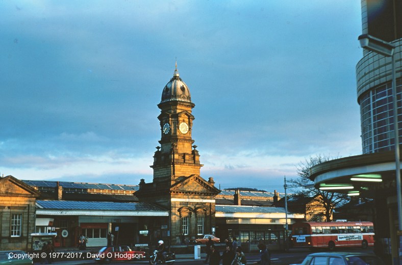
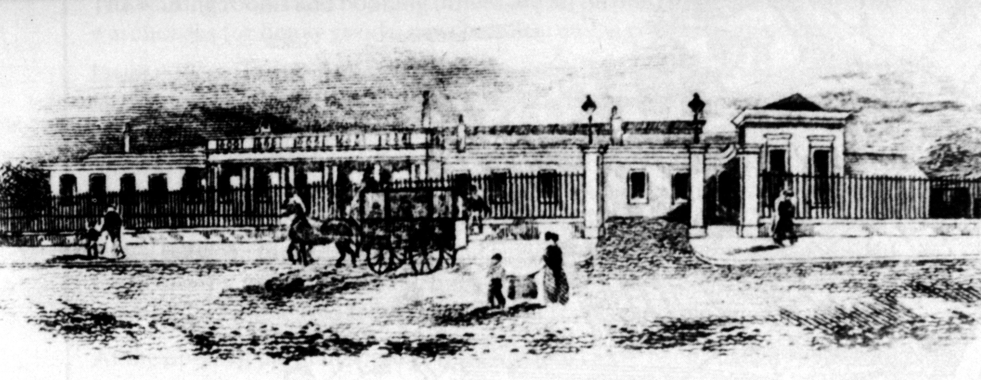
In a previous post, I showed how the architecture of Scarborough Central Station was redeveloped from the simple neoclassical design of 1845, to the ornate high-Victorian “wedding cake” that still survives today.

Of Lost Maps & Lost Towns

East Yorkshire Wall Map, Bridlington, 1977

East Yorkshire Wall Map, Bridlington, 1977

The Map shown above in my 1977 photograph was for many years displayed on a wall that overlooked the Promenade Bus Station in Bridlington. I was recently scanning some old photographs, and that led me to wonder what had become of the map, and indeed the bus station below it.

At the time of my birth, Bridlington was in the county of the East Riding of Yorkshire, then, in 1974, that became part of the unloved county of Humberside. In 1996, Humberside was abolished, and Bridlington found itself once again in the East Riding of Yorkshire.

The local bus company in Bridlington was, and still is, East Yorkshire Motor Services (EYMS), which created and maintained the map. EYMS is perhaps most famous for the unique “Gothic” roofs of its double-deck buses, which were specially shaped to fit through the North Bar in the East Riding county town of Beverley. (See this article for a photo of one of the gothic buses squeezing through the bar.) Built in the 15th century, Beverley Bar still exists today, as shown in my 2007 photo below, and is the only remaining brick-built town gate in Britain.

Beverley Bar, 2007

Beverley Bar, 2007

The photo below shows a general view of Bridlington bus station at around the same time as the color photo of the map above.

Bridlington Promenade Bus Station, 1977

Bridlington Promenade Bus Station, 1977

EYMS built the bus station during the 1930s, and the main building was finished in pleasant blue and cream tiles, reflecting the company’s bus liveries, which also used shades of blue and cream.

Unfortunately, the privatization of the British bus industry during the 1980s made such town-centre sites prime targets for sale and redevelopment, as the privatized companies saw opportunities to “externalize their costs” by selling off their own premises and stopping their vehicles on the streets instead, causing further traffic congestion.

Bridlington Bus Station suffered this fate, and closed down years ago, but I wondered what had become of the site. Looking on Google Streetview, I was initially unable to spot any evidence of the location. Eventually, however, I noticed that, even though the station is gone, the building on which the map was painted still exists, and is now a very tatty branch of Boots. Here is the latest Streetview image.

For convenience, here’s an excerpt from that view. You can see the gable end of the building on which the map was painted, and even the finial is still there!

Site of Bridlington Promenade Bus Station

Site of Bridlington Promenade Bus Station

As you can see, the “Promenades” shopping center has been built over the site of the Bus Station. I’m not sure it’s much of an improvement…

They Keep Losing Towns Too!

The East Riding of Yorkshire actually continues to suffer more significant losses of property than just Bridlington Bus Station and its map.

As a teenager, I was a fairly frequent visitor to Scarborough Library, which had some obscure old books about Yorkshire history.

One of these books was “The Lost Towns of the Yorkshire Coast” by Thomas Sheppard, published in 1912. The book describes the severe coastal erosion in East Yorkshire, south of Bridlington. While Bridlington itself is built on the same chalk that forms the Flamborough promontory, the area southwards to Spurn Point (called Holderness) is a soft glacial moraine, which the sea is eroding away very quickly.

The map below is from the frontispiece of the 1912 book, and shows the medieval and modern coastlines of the county. The loss of entire towns due to erosion is quite obvious.

Lost Towns of East Yorkshire

Lost Towns of East Yorkshire

Short of building a sea wall all the way along the coastline, the erosion process is really unstoppable. In the future, there will presumably be some towns and villages sitting on peninsulas where defences have been built locally (such as at Withernsea), but the remainder of Holderness will eventually just be washed away.

The most recent losses of property have been around Aldbrough, as shown in these photos. See it while you can!

Incidentally, Beverley in Yorkshire has no connection to Beverly Hills in California, although the different spellings do sometimes trip people up!

Tomorrow Never Knows

Stories of Mr Wolf, 1966

Stories of Mr Wolf, 1966

Last week, Mary and I went to see the movie of Scott Freiman’s lecture Tomorrow Never Knows: Deconstructing the Beatles (Revolver).

The Beatles created their famous album “Revolver” during the summer of 1966. I’m afraid that my artistic creations during that summer were less sophisticated, probably because I’d just turned six at the time. Above is an illustration from my 1966 book “Stories of Mr Wolf”. According to a date on the page, the drawing was created on Sunday, July 3rd of that year.

The stories turned out to be rather short, and much less psychedelic than the Beatles’ music! Mind you, they did involve talking wolves who visited Scarborough, so they could have been described as being “far out”…

I scanned the surviving contents of my 1966 book recently. As you can see, the paper is becoming extremely yellow, and it’s very fragile. Fifty more years from now, the whole thing will probably have turned to dust, but then so will I!

When I penned that drawing, back in July 1966, my father was the same age that I am now. Did I imagine then that, fifty years later, I’d be scanning my drawing into a digital image, then posting it on a publicly-networked page for all the world to see? Of course not! I wouldn’t even have known what those concepts were. That wasn’t just because I was only six years old at the time, since I’m sure that my parents would not have understood those concepts either. There were contemporary TV shows that attempted to predict what life would be like in the twenty-first century, such as Thunderbirds, but all of those shows completely missed the emergence of the internet. It really was a case of “Tomorrow Never Knows”…

Airspeed York

Former Airspeed Factory, York, in 1979

Former Airspeed Factory, York, in 1979

During an Easter 1979 visit to York, I sought out and photographed the rather tatty and unremarkable building shown above. On close examination, the exterior revealed some vaguely “Art Deco” embellishments, but in general it gave the impression of being just another old warehouse.

The building was located on Piccadilly, York, and was in use as Reynard’s Garage in 1979. It had originally been built as a trolleybus garage in the early 1920s. In 1931, after the trolleybuses had been relocated to larger premises, the building took on a new function as the home of Airspeed Ltd., an aircraft manufacturing company founded by, among others, Nevil Shute and Amy Johnson.

By 1933, Airspeed were ready to expand into larger premises, but York Corporation refused to provide any assistance. Other municipalities around the country took a more enlightened view, and so Airspeed were tempted away from York to Portsmouth, where they built large new premises, then went on to design and build many successful aircraft designs, such as the Oxford and Horsa.

Sadly, in 2015 the now-derelict building was finally demolished, despite public pressure to save it. Perhaps York Corporation wanted to rid themselves of this daily reminder of their own lack of foresight back in the 1930s?

This link displays the current Google Streetview of this location.

Indiana Jones & the Treasure Island

Administration Building, Treasure Island

Administration Building, Treasure Island

There are many islands in San Francisco Bay, and most of them are natural. There is however one artificial island that has a short but intriguing history. It’s called Treasure Island, and it was built during the 1930s as the intended location of San Francisco Airport.

The Administration Building on Treasure Island enjoyed its “fifteen minutes of fame” (or less) in the movie Indiana Jones and the Last Crusade, when the airport terminal building was dressed up to portray “Berlin Airport”. The remainder of its existence has mostly been quiet, but its fascinating Art Deco architecture remains on public view to this day.

The first use of the new island was not as an airport, but to host the 1939 Golden Gate International Exposition. The island’s airport facilities were used by PanAm’s Clipper flying boats, which moored at Clipper Cove (aka the Lagoon of the Trade Winds), between Treasure Island and Yerba Buena Island. This information is missing from the Wikipedia article, but I have a copy of a 1939 color movie titled Trans-Pacific, which shows PanAm passengers arriving at the terminal and boarding a Boeing 314 clipper, which then leaves from Clipper Cove.

After the start of World War II, the US Navy took over the island as a base, swapping the land for its existing base at Mills Field on the Peninsula. As a result, after the War the new San Francisco Airport was developed at Mills Field (which was just as well, because Treasure Island would have been impossibly small). The surviving Boeing 314s actually flew from the shoreline at Mills Field for a short time in 1945-46.

During the 1990s, I was a member of the Treasure Island Museum Association, and was involved with efforts to maintain the museum that was located in the Administration Building, so I visited the island quite frequently, and took the photographs shown in this post. Unfortunately, the museum closed in 1997, due to lack of financial support, but, now that the City of San Francisco owns the building, there are plans to reopen it.

View of Bay Bridge and San Francisco from Treasure Island

View of Bay Bridge and San Francisco from Treasure Island

The spectacular view from the Administration Building towards San Francisco and the Bay Bridge.

Treasure Island with Mustang

Treasure Island with Mustang

The Administration Building one summer evening, with my Mustang parked in front.

Sunset over the Golden Gate from Treasure Island

Sunset over the Golden Gate from Treasure Island

Goodnight from Treasure Island! Sunset over the Golden Gate, from the car park in front of the Administration Building.

Air Control & the Legacy of Empire

Avro Shackleton AEW.2, 8 Squadron RAF, on display in the RAF Museum

Avro Shackleton AEW.2, 8 Squadron RAF, on display in the RAF Museum, 1983

I just finished reading a fascinating book called Wings of Empire, which details the operations of the Royal Air Force in various minor conflicts between the two World Wars. It’s very detailed but also very readable, which isn’t always the case for history books. The book describes the policy of “Air Control”, which, at end of World War I, was seen by the British government as a low-cost method of policing the vast territories of the Empire.

It seems that this aspect of history is unpopular in some circles these days, due to its overtones of imperialism, or even racism. Nonetheless, for better or worse, these events did happen. In fact, even now in the twenty-first century, the Western World is still dealing with the fallout from those events. The establishment of Israel and other countries in the Middle East all stem directly from the events of those times, and conflicts resulting from that are ongoing.

Aside from their general historical interest, those events impacted my family as a result of my father’s unwilling involvement during World War II. His birthday was on March 6th–he’d have been 108 today–so this seems like an appropriate date on which to post these thoughts!

When war was declared in September 1939, my father was running an electrical business in Leeds. The issue of conscription was obviously of concern to him, but someone gave him a hot tip. They told him that, if he signed up for military service voluntarily, rather than waiting to be conscripted, it would confer two advantages:

  1. He could choose which service to join,
  2. He could choose the location where he would serve.

This seemed like great news. He decided to sign up with the RAF (which was the most glamorous service), and to specify that he wanted to serve at Church Fenton airfield (near York). That way, he’d be able to maintain his electrical business on his days off from the RAF. So, he went along and signed up.

The hot tip turned out to be half-right. He was able to enroll in the service of his choice. However, when his callup papers arrived, he discovered to his horror that he would be serving not in Church Fenton, but with 8 Squadron in… Aden.

8 Squadron had been involved in Air Control operations since the early days of the policy, and in fact continued to be associated with Aden until Britain left the area. My father made it through the war, somehow surviving threats from disease, enemy action, bad luck, and outright incompetence. Some of 8 Squadron’s exploits have been well-documented, but he had some extra details to add to some of those accounts!

The photo above shows an Avro Shackleton AEW.2 that served with 8 Squadron, and carries the squadron’s Arabian dagger (Khunjah) emblem on the nose. Of course, the Shackleton didn’t appear until after World War II, so my father never flew on that type of aircraft, but 8 Squadron is still in existence today.

A Visit to the Antique Society

The Antiques Society premises in Sebastopol

The Antique Society premises in Sebastopol

This afternoon, I visited the Antique Society collective in Sebastopol, shown above. There are usually some interesting items available there, and on this occasion I found a couple of pieces of ephemera. Every time I visit, I can never be sure what I’ll find.

The building itself is quite interesting, being one of the few Art Deco structures in the Wine Country. It was originally the Henderson Furnace Factory, and was presumably cutting-edge architecture when it was built in the 1930s.

Today, I found two interesting historical items. The first is an old postcard of the Tokyo Imperial Hotel. This is a famous building, designed by Frank Lloyd Wright. The postcard is also quite well-known, and a copy appears on the Wikipedia page describing the hotel. My copy is unused, but it’s fairly easy to date it and understand why it’s unused, because there’s an imprint on the back.

Tokyo Imperial Hotel Postcard

Tokyo Imperial Hotel Postcard

The 1940 Tokyo Olympic Games never took place, being canceled because of World War II. Looks like this postcard was printed in anticipation, and then found to be useless!

My other lucky find originated on this side of the Pacific Ocean. It’s a small advertising flyer for several San Francisco area attractions. The flyer is dated in pencil “1911”, and includes an advertisement for the Triangle Trip, which was a rail journey that you could take from the ferry terminal at Sausalito, and which was very popular until the growth of personal motoring in the 1920s.

triangletripad1911

Triangle Trip Rail Route, 1911

You could take the North Western Pacific route from Sausalito (right hand side of the triangle) to Fulton, then the Fulton & Guerneville Railroad along the Russian River (top of the triangle) to Monte Rio, and finally return via the North Pacific Coast railroad (left hand side of the triangle).

The narrow-gauge North Pacific Coast route closed completely in 1930, which removed one side of the triangle. Perhaps amazingly, the North Western Pacific on the right-hand side of the triangle still exists, and SMART trains will start running on part of the route (from San Rafael to beyond Fulton) later this year.


Latin Names in Yorkshire

york1964-300cright

York from the City Walls, August 1964

There are many stereotypes of Yorkshire, with varying degrees of truthfulness, but I suspect that people rarely, if ever, associate Yorkshire with Latin. As a child, growing up in Yorkshire, however, I learned that there is a definite Latin influence in the county, at least as far as place names are concerned.

My father photographed the above view of York long ago, but you can still take the same view today, and little has changed there, except for the traffic.

I realize that the conjunction of the concepts “Yorkshire” and “Latin” may conjure up visions of a red-faced George Whitebread (Harry Enfield’s Yorkshireman character) declaring something like, “Latin? Don’t talk to me about Latin. I’ve been to Benidorm!”, but that’s not what I’m thinking of here.

In fact, there are many placenames in Yorkshire that are directly or indirectly derived from Latin words. Some of the “indirect” derivations stem from the Old French or Anglo-Norman languages, which were themselves descendants of Latin.

Roman Legacy

On reflection, the occurrence of Latin names anywhere in England shouldn’t really be surprising, since Yorkshire and the rest of what’s now England were a part of the Roman Empire for several hundred years.

Typically, where the Romans developed an existing settlement, they would name it by Latinizing its existing local name. In what’s now England, those names are typically of Celtic origin, and in many cases the Celtic meanings of the names remain unknown.

The Roman names of many English settlements are known, but in general those names are no longer in use, having been replaced by new names created by later settlers. However, there are a few cases where the Latin name has survived in a more or less obvious form.

As an example that’s not in Yorkshire, the name Lincoln is probably closest to the Latin original, which was Lindum Colonia. All you need to do is to cross out a few letters!

Roman Column in York, which was originally part of the Basilica. It was found under York Minster, in the background

Roman Column in York, which was originally part of the Basilica. It was found under York Minster, in the background

The name of Yorkshire’s capital city, York, is of Latin origin, but less obviously so. The Latin name was Eboracum, which was probably derived from the Celtic Caer Ebruac. The Roman name was changed to the Old English Eorforwic, and then to Jorvik by the Vikings. The current name is just a modified version of Jorvik.

As a schoolchild in Yorkshire, it was drilled into me that a person from York is not referred to as a “Yorker”, or anything like that, but as an Eborian, because of the Latin name of the city.

Religious Influence

Following the Norman Conquest, England and parts of what is now France were unified under a single king, as the Angevin Empire. As a result, cultural influences from the continent began to drift into England. At that time, religious houses such as monasteries were the repositories of much learning and tradition. The language of the Western church was still Latin, so there was a natural tendency to apply Latin names to objects.

The language of the Norman court was Anglo-Norman, which was itself a derivation of vulgar Latin. French is one of several modern European languages that are derived from Latin, and are known collectively as Romance languages.

The Ruins of Rievaulx Abbey, Yorkshire, in 2008

The Ruins of Rievaulx Abbey, Yorkshire, in 2008

Usually, when a new monastery was founded, it would adopt the existing local name. However, sometimes monasteries were founded in previously-uninhabited places, so a new name had to be invented. This happened at Rievaulx, where the modern name is a corruption of the Latin Rye Vallis. The pronunciation of the name has also changed over the years; the current pronunciation is “Ree-voh”, but it seems that this was a change that occurred only after the majority of the population learned to read, and discovered how the word is spelled. Prior to that, the accepted pronunciation was apparently “Rivers”.

Latin prefixes and suffixes have also been applied to some placenames. The suffixes Magna and Parva are used in Yorkshire and in other counties. However, one Latin suffix that seems to appear only in Yorkshire applies to the neighboring villages of Low Hutton and High Hutton, which together are known as Huttons Ambo (and which was the name of their railway station). During my recent Spanish lessons, I learned that the Spanish for “both” is ambos, because of course Spanish is another of those Romance languages.

Another Old French name that appears in Yorkshire is that of the village of Grosmont. In this case, the village is named after a medieval priory that was founded at that site by a religious order based in what is now France. Scenes around Grosmont featured quite regularly in the ITV police drama Heartbeat, and the location of the fictitious town Ashfordly corresponded to that of Grosmont.

The Norman Influence: Radio Active

Writing this article reminded me of a sketch from the 1980s-vintage BBC radio comedy show Radio Active.

As part of the “God Alone Knows” show, DJ Martin Brown is interviewing church warden Clifford about the history of St. Littlebody’s Church:

Martin Brown: “This is not a new church, is it? Is it eighteenth century, Clifford?”

Clifford: “No it’s Norman in fact”

Martin Brown: “Oh I’m sorry. Erm, is it eighteenth century, Norman?”

Clifford: “The church is Norman”

Martin Brown: “Oh I’m sorry. So, Clifford, how did you come to call the church Norman?”

Clifford: “I didn’t call the church Norman”

Martin Brown: “Oh no, sorry. Silly me. It was probably called Norman hundreds of years ago, wasn’t it? Possibly by the Normans, who knows?”

You can hear this sketch in its full glory, along with the rest of the Radio Active episode “God Alone Knows”, at this site:

https://archive.org/details/RadioActiveBBC

Scarborough Railway Station: A Historical Mystery Tour

Scarborough Central Railway Station in 1977

Scarborough Central Railway Station in 1977

During my teenage years, for my A-level Art study of architecture, I did some original research on the history of Scarborough [Central] Railway Station (shown above), which led to a surprising conclusion about the building’s original appearance.

My conclusions were questioned at the time, but were verified decades later by someone else’s chance discovery.

It was always a well-known fact that Scarborough’s main railway station was built in 1845 (quite early in the history of railways), at a location that was then outside the town limits. It’s also well-known that, in 1882, a central tower was added to the frontage. Surprisingly, and despite the efforts of various developers over the decades, the station building has survived to this day in essentially its 1882 form, as shown in my 1977 photograph at the top of this article.

During my researches at Scarborough Reference Library, I discovered a copy of a catalog for an exhibition called “Marble Halls”, which had apparently taken place at the Victoria & Albert Museum in London in 1973.

Marble Halls

An 1844-dated illustration in the Marble Halls catalog showed a plan of “Scarborough Station” that, at first glance, looked nothing like the existing structure. The image below is the copy of the catalog illustration that I created for my study.

Copy of Plan of Scarborough Station, 1844

Copy of Plan of Scarborough Station, 1844

I hadn’t expected to see the central tower, of course, but where are the three small pavilions in the building’s frontage? The plan also shows a colonnaded central entrance, of which there’s no trace in the existing building.

My initial impression was that this plan did not represent the station as built, but I was puzzled that the accompanying commentary did not mention any discrepancy between the plan and the structure as-built.

I wrote to some local experts on the subject, who provided me with the limited historical references that were available. None of this provided any clear details regarding alterations to the building, except for the addition of the tower. The general opinion seemed to be that the entire frontage of Scarborough Station had probably been rebuilt in 1882 (rather than just the tower), but there was no evidence to prove that claim. One expert pointed out that the architect’s illustration in “Marble Halls” may have been nothing more than an “architect’s impression”, and that there was no guarantee that the station as-constructed had ever resembled that plan.

Some Detective Work

If in fact the building’s frontage had been substantially altered in 1882, it struck me that perhaps I could find some evidence of that (although it seemed odd that nobody would have previously noticed anything).

I walked around the outside of the building, examining its architectural details. I looked particularly at the locations that would be the junctions between the 1845 structure and what were potentially later alterations. Eventually, at the East end of the joint between the easternmost pavilion and the main trainshed (on the far left in the heading photo), I found a mismatch in the details of the pediment, as shown in my sketch below.

Scarborough Station. Detail of Trainshed Pediment stonecarving

Scarborough Station. Detail of Trainshed Pediment stonework

The mismatched joint shown above would have occurred where the new pavilion was added to the main wall of the original building, if my suspicions about the station’s original appearance were correct.

Given the immense precision of the building’s stone carving, it seemed impossible that such a noticeable mismatch would have occurred (or be allowed to remain) during the original construction. It seemed much more likely that this mismatch occurred because of some miscalculation when new stone was carved later, the intention having been to match the details of the original building.

Conclusion & Confirmation

In my study, I presented my conclusion that the 1844 architectural plan did indeed show the original appearance of Scarborough station, but that the building had been subject to greater subsequent alteration in the 1880s than most people had suspected. Not only was the central tower added, but most of the original frontage had been removed, and replaced with the three small pavilions that still exist.

At the time, I had no evidence to support my assertion, except for the architectural plan and my own illustrations of the architectural details of the actual building. Thus, my conclusion remained unproven, and nothing more than an “interesting speculation”.

In 1995, long after the completion of my Art A-level, and by which time I’d moved away from Scarborough, first to London and then to California, one of my expert correspondents from 1977, J R Lidster, published his own book on Scarborough Railway Station. In that book, he included a drawing of the station frontage from a letterhead that had recently been discovered in the attic of a property in Scarborough.

Sure enough, the letterhead showed a building that closely matched that depicted in the 1844 plan in the book “Marble Halls”, thus finally verifying the conclusion of my investigation.

[Added 12/14/24] Here is the letterhead described above, from J R Lidster’s book:

Early View of Scarborough Railway Station. Copyright J R Lidster

A Sense of History

At the age of thirteen, I was forced to select a restricted range of subjects at school for continued study, as preparation for taking “O-level” examinations. One of the subjects that I dropped was history, because my naïve belief at that time was that history was “already written down”, and thus there was nothing new to add. Even at that age, I knew that, whatever I was going to devote my life to, I wanted it to be something innovative.

The experience that I described above, where I was able to provide original insight into a historical problem, showed me that my earlier view of history had been wrong. The events under consideration were, after all, relatively recent history, dating back only about one century, and yet many details were unrecorded, and there were new contributions to be made. I was able to offer new information without even “getting my hands dirty”!

Postscript: More Marble Halls

This incident was my first encounter with the contents of the “Marble Halls” catalog. The book also contains illustrations of other Victorian buildings that featured in my later life. For example, there’s an illustration of the Imperial Institute in London, the buildings of which were subsequently incorporated into Imperial College, from where I would graduate.

The book also includes an image of Highclere Castle, in Hampshire, which was close to my home in Andover in later years. Highclere Castle is now world-famous as the fictitious Downton Abbey.

Michael Palin & the Life of Brian: Insights from my Interview

A Defiant Stance!

A Defiant Stance!

In 1983, while a student at Imperial College, I taped a video interview with Michael Palin, of “Monty Python” fame. At that time, the Monty Python team’s most famous—if not notorious—movie to date had been “The Life of Brian”, which had been released in 1979. Controversial at the time, the movie is perhaps even more famous now, having regularly been cited as the “greatest comedy film of all time”. If you can remember back to that time, you may recall that “The Life of Brian” was vociferously denounced in some quarters as being “blasphemous”.

As our interview progressed, I broached the topic by mentioning to Michael* that there had been controversy about the movie “where I was living”. His immediate response was, “You’re not from Harrogate, are you?” I laughed, but had to admit that I was in fact from nearby Scarborough (both towns being in North Yorkshire, England). He replied along the lines of, “Well, Harrogate seemed to be the worst when it came to the intellectual level of debate”.

Michael acknowledged that the team had anticipated some controversy when planning the movie: “We realized that some people would claim that Brian was supposed to be Jesus, so we deliberately included Jesus alongside Brian, to make it clear that he wasn’t.”

As it turned out, the reality was that all too many were willing to denounce the movie without even having seen it. In fact, as is surely obvious to anyone who takes the trouble to watch it through, the plot pokes satirical fun at religions, organizations, and many other topics that you’d expect the Monty Python team to address. The petulant reaction simply provided extra publicity for the movie, and discredited those who complained about non-existent offences.

Perhaps among the most insightful aspects of the movie is the lampooning of the way in which, having committed themselves to a particular belief, some people will go to extremes to avoid having to accept any evidence that the belief is wrong. Instead of reaching the logical conclusion, believers go out of their way to create and justify the most implausible rationalizations, redefining words and concepts as necessary to avoid admitting error.

I found Michael Palin’s comments during our interview interesting and personally thought-provoking, since he was correct that there had been much sanctimonious hand-wringing about the movie in my home town (and in many other places too). The end result of all that, in my case, was to make me realize that even some supposedly-intelligent people whom I knew couldn’t necessarily be trusted to behave rationally when it came to the “big issues”. That was a lesson that I’ve carried with me ever since.

(* Just in case it seems presumptuous of me to refer to my guest simply as “Michael”, I should mention that he gave me explicit permission to do that! He told me, “Only my parents call me Mr. Palin”…)